Today for class and we headed out to the Litchfield Mine in Eau Claire, WI. Our class intended in collecting GCPs for a series of flights to be flown by Peter Menet of Menet Aero. The objective of the flights was to calculate new stock piles of various aggregate piles from the mine site (Fig. 1).
 |
| (Fig. 1) Aggregate piles within the Litchfield Mine Site. |
Due to an unforeseen issue with the GPS we intended to collect the GCPs with we were unable to gather any GCPs for the site. In the future our class will be exploring calibrating these images with previous images which were captured with GCPs to see if we can obtain the same accuracy without collecting GCPs every flight.
Methods
The flights were conducted by Menet utilizing his DJI hexacopter (Fig 2). The hexacopter was rigged with Sony ILCE 6000 digital camera (Fig 3).
 |
| (Fig. 2) DJI hexacopter owned by Menet Aero. |
 |
| (Fig. 3) Sony ILCE 6000 rigged on the DJI hexacopter. |
Menet flew 3 different missions to assess the results of flights with various heights and quality of images. Menet flew the flights with the following parameters.
- 200 ft elevation and 12 megapixel resolution
- 200 ft elevation and 24 megapixel resolution
- 400 ft elevation and 24 megapixel resolution
The missions were created utilizing a mission planner software created by DJI (Fig 4). The DJI software is very similar to the Mission Planner software which I have utilized in past blog post.
 |
| (Fig. 4) DJI mission planner software with one of the flight plans open. |
After all of the flights were conducted I input the collected data in to Pix4D and created an orthomosaic image for each of the flights.
Results
 |
| ( Fig. 5) Zoomed in image of the results from the 12 MP and 200 Foot elevation flight. |
 |
| (Fig. 6) Zoomed in image of the results from the 24 MP and 400 foot elevation flight. |
 |
| (Fig. 7) Zoomed in image of the results from the 24 MP and 200 foot elevation flight. |
Additionally, I wanted to compare the results of volumetrics of a stock pile between the images. I utilized the volume tool in Pix4D to calculate the volume (Fig. 8).
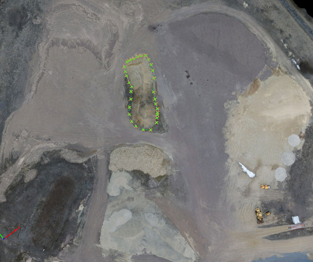 |
| (Fig. 8) Way points from Pix4D to calculate volume from. |
 |
| (Fig. 9) Display of the volumes taken from all three images. |
Discussion
From examining Fig. 5-7, I feel the 24MP image collected at a 200 foot elevation had the best image quality. The 12MP image collected at a 200 foot elevation had the second best image quality. The 24 MP image collected at a 400 foot elevation had the worst image quality of the three. While image quality is one aspect I was examining, I am also taking in to concideration the amount of time it takes to process the image. The initial processing times in Pix4D are as follows:
From examining Fig. 5-7, I feel the 24MP image collected at a 200 foot elevation had the best image quality. The 12MP image collected at a 200 foot elevation had the second best image quality. The 24 MP image collected at a 400 foot elevation had the worst image quality of the three. While image quality is one aspect I was examining, I am also taking in to concideration the amount of time it takes to process the image. The initial processing times in Pix4D are as follows:
- 24MP (200 ft) : 1 hour 25 minutes and 15 seconds
- 24MP (400 ft) : 32 minutes and 21 seconds
- 12MP (200 ft) : 39 minutes and 2 seconds
I was hoping to keep track of the full processing time between all three of the images. Unfortunately, my schedule did not allow me to babysit the computer to track the full processing time of any of the images. So my judgments will be based off the above processing times. I feel the 12MP @ 200 ft has the ability to be the go to set up depending on the application. Obliviously, the 24MP @ 200 ft offers a better resolution. Most applications will not require the resolution of the 24MP for the desired results of the project.
Conclusion
You will need to consider the desired out come for your project when deciding on what the quality of your imagery should be. Each sensor will result in different outcomes. Testing your specific platform and sensor will give you the best knowledge for selecting the best parameters.
No comments:
Post a Comment